Types and Causes of Flooding in Palm Beach County
Back to Flood Directory
Palm Beach County Flooding
As a relatively flat, low lying, heavily developed coastal county that experiences frequent intense rain events and periodic tropical storms, Palm Beach County is especially susceptible to flooding.
Palm Beach County flooding has historically taken one of the following forms:
- Flash flooding resulting in the rapid buildup of flood waters from intense localized precipitation that exceeds drainage capacities
- General flooding resulting from a buildup of water levels over time
- Water body overflows resulting from excessive rainfall or water management actions
- Coastal surge flooding driven by storm-force winds
- Dike breaches or overtopping related to major rain and tropical storm events
Causes of Local Flooding
Significant factors contributing to inland flooding include rainfall intensity, rainfall frequency, rainfall duration, surface conditions, topography, and inadequate natural drainage.
Palm Beach County’s torrential rains, low and flat terrain, and large number of inland water bodies, conspire to create a significant probability for inland flooding. An additional, increasingly significant, contributing factor is rapid water runoff associated with the vast areas of impervious surfaces created by new development, creating flood prone areas where they did not previously exist.
In urban areas, grates and drains can become overtaxed or blocked with debris, leaving no space for excess water to enter drainage and sewer systems.
According to the South Florida Water Management District, “Many new residents to Palm Beach County are alarmed when they see standing water in streets or driveway swales. In other places, that could be a cause for concern, but in our region, it's something you can expect to see after a soaking summer shower.”
Palm Beach County averages over 60 inches of rain a year and more than 130 rain days, with most of it coming between the months of June and November. Most developed areas are clustered along the coasts or near large waterways. Virtually flat, with most areas at or only slightly above sea level, even moderate rains can accumulate quickly.
The Water Management Challenge
Rainfall has been critical to South Florida’s history, feeding its natural wetlands and refreshing surface-water and groundwater reservoirs. Its water management issues differ from those of most other areas in the country. Where most areas are concerned with protecting “scarce” water resources, South Florida’s challenge is managing an overabundance of surface water. In order to drain and manage the excess water, hundreds of miles of canals, dikes, and levees have been built. Water management policies have created agricultural, tourism, and real estate industries whose success has fueled the state's population growth and taxed the seemingly abundant water supply. Now choices must be made between further population growth, environmental protection, and an adequate, safe water supply.
The area’s high hydrologic variation, low physical relief, and limited storage and conveyance capacities, make water management challenging. A delicate balance must be struck, dealing with extremes: flooding versus drought and open land versus crowded urban areas. Actions range from enforcing water restrictions during dry periods to precautionary or emergency flood management during wet periods and storm events.
With annual rainfall averaging over 60 inches (but varying widely), and more than 50 percent occurring in 4 months (June to September)… with the rainy season necessitating the movement of water away from populated areas for flood control and the storage of excess water necessary to meet population needs and demands during dry periods… water management is a complex challenge.
County Elevations
Terrain throughout the Palm Beach County is relatively level. The mean elevation is 15 feet above sea level. Ocean coastal beachfront gradually slopes up to a dune line with top elevations of 12 to 23 feet. From the dune line there is a gradual downward slope to lake and inland waterway frontage with a width of from a few hundred feet to a half mile. From there, land slopes upward to a coastal ridge then downward to elevations of 5 to 12 feet in a drainage valley. Further inland, elevations remain relatively stable.
Primary Surface Water Areas
Lake Okeechobee, the largest fresh water lake after the great lakes, is South Florida's primary water reservoir. Approximately 250 square miles of the lake are within the geographical boundaries of Palm Beach County. Other sizeable bodies of water include Lake Mangonia (540 acres) and Clear Lake (401 acres) in West Palm Beach and Lake Osborne (356 acres) in southern Lake Worth and northern Lantana.
The West Palm Beach Canal connects Lake Okeechobee and Lake Worth. A vast network of canals is interconnected with the West Palm Beach Canal. A system of lakes runs north and south within 8 miles of the east coast. The Loxahatchee River system is located in the northern section of the county and is interconnected with the Loxahatchee Slough.
The map below shows the relative distribution of primary surface water areas within Palm Beach County
Natural & Beneficial Flood Water Storage Areas
The following areas, designated as "Environmentally Sensitive lands" are undisturbed natural areas of Palm Beach County that act as natural storage areas for flood waters, reduce the possibility of flooding nearby residences, and help to recharge the groundwater aquifer.
| NAME | TOTAL ACRES |
| Acreage Pines Natural Area | 115.61 |
| Arthur R. Marshall Loxahatchee National Wildlife Refuge | 143953.77 |
| Blazin g Star Preserve | 24.14 |
| C-18 Triangle Natural Area | 138.7 |
| C-51 and L-8 Reservoir | 1263.73 |
| Carlin Park | 120.31 |
| Coral Cove Park | 31.42 |
| Cypress Creek Natural Area | 2083.12 |
| Cypress Creek/Loxahatchee | 3547 |
| Cypress Knee Slough Preserve | 29.31 |
| Delaware Scrub Natural Area | 15.8 |
| Delray Oaks Natural Area | 24.5 |
| DuBois Park | 18.69 |
| Dupuis Reserve | 21891.61 |
| East Coast Buffer | 20757.95 |
| East Conservation Area | 195.93 |
| Everglades Agricult ural Area | 52125.5 |
| Everglades and Francis S. Taylor Wildlife Management Area | 671831 |
| Florida Atlantic University Ecological Site | 91.6 |
| Fr en chm an's Forest | 173.15 |
| Gentle Ben Flowage Easement | 334.81 |
| Gopher Tortoise Pr eserve (City of Boca Raton) | 8.8 |
| Grassy Waters Preserve | 12800 |
| Green Cay Nature Center and Wetlands | 100 |
| Gumbo Limbo En vir o n m e nt al Complex | 20 |
| Herbert Hoover Dike | 774.8 |
| High Ridge Scrub Natural Area | 39.26 |
| Holey Land Wildlife Management Area | 35350 |
| Hungryland Slough Natural Area | 2895.29 |
| Hungryland/ SFWMD Parcels | 7859.99 |
| Hypoluxo Scrub Natural Area | 96.71 |
| Indian Mounds | 436.25 |
| J. W . Corbet t to Loxahatchee NWR Connector | 35 |
| J. W. Corbett Wildlife Management Area | 60348 |
| Jackson Riverfront Pines Nat ural Area | 3.01 |
| John C.& Mariana Jones/ Hungryland Wildlife & Environmental Area | 12735 |
| John D. MacArthur Beach State Park | 437.57 |
| Jonathan Dickinson State Park | 11458.68 |
| Juno Dunes Natural Area | 577.7 |
| Juno Park | 18.2 |
| Jupiter Beach Park | 46.49 |
| Jupiter Inlet Lighthouse Outstanding Natural Area | 126.28 |
| Jupiter Mangroves Natural Area | 0.92 |
| Jupiter Ridge Natural Area | 271.32 |
| Lake Harbor Tract | 632 |
| Lake Okeechobee Connector | 7.73 |
| Lake Park Scrub Natural Area | 54.93 |
| Leon M. Weekes Environmental Preserve | 12 |
| Limestone Creek Natural Area | 51.62 |
| Loggerhead Park | 17.26 |
| Loxahatchee Slough Natural Area | 12838.32 |
| Loxahatchee Slough Public Use Natural Area | 640 |
| Loxahatchee Slough Research Natural Area | 2560 |
| Lynn University Scrub | 11.46 |
| Morikami Museum and Japanese Gardens | 188.53 |
| North Jupiter Flat woods Nat ural Area | 146 |
| North Ocean Ridge Mangroves Natural Area | 8.69 |
| Ocean Ridge Hammock Park | 8.54 |
| Ocean Ridge Natural Area | 12.35 |
| Okeeheelee Park North | 900 |
| Okeeheelee Park South | 812 |
| Pahokee Marina and Campground | 30 |
| Paw-Paw Preserve | 3 |
| Pine Glades Nat ural Area | 6641.98 |
| Pine Jo g Environmental Education Cent er | 150 |
| Pond Cypress Natural Area | 1736.18 |
| Pondhawk Nat ural Area | 78.7 |
| Radnor | 153.7 |
| Red Reef Park | 67 |
| Riverbend Park | 680 |
| Rosemary Ridge Preserve | 7.29 |
| Rosemary Scrub Natur al Area | 13.59 |
| Rotenberger Wildlife Management Area | 29297 |
| Royal Palm Beach Pines Natural Area | 773.23 |
| Seacrest Scrub Natural Area | 53.69 |
| Serenoa Glade Preserve | 9 |
| Snook Islands Natural Area | 117.65 |
| South Beach Park | 24.77 |
| South County Regional Park | 314.46 |
| South Inlet Park | 11.1 |
| Spanish River Park | 94.4 |
| Stormwater Treatment Areas | 47605.32 |
| Strazzulla Tract | 2701 |
| Sweetbay Natural Area | 1094 |
| Wellington/Acme Marsh | 363.61 |
| Winding Waters Natural Area | 550.01 |
| Yamato Scrub Natural Area | 216.7 |
| TOTAL AREA (in acres) | 1,176,895.73 |
The map below shows these natural and beneficial flood water storage areas: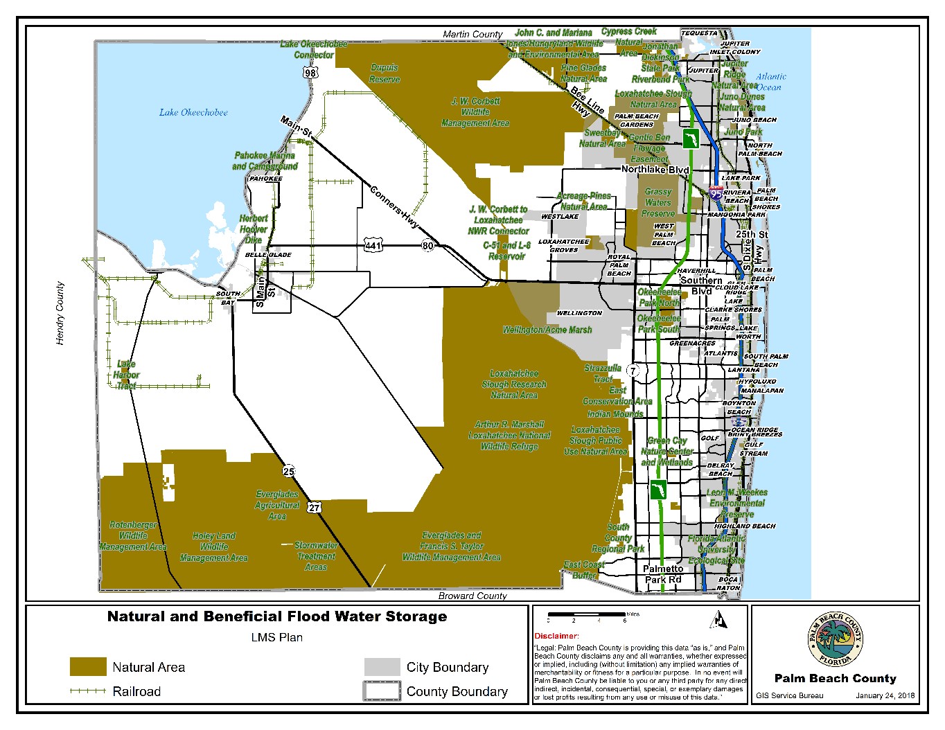
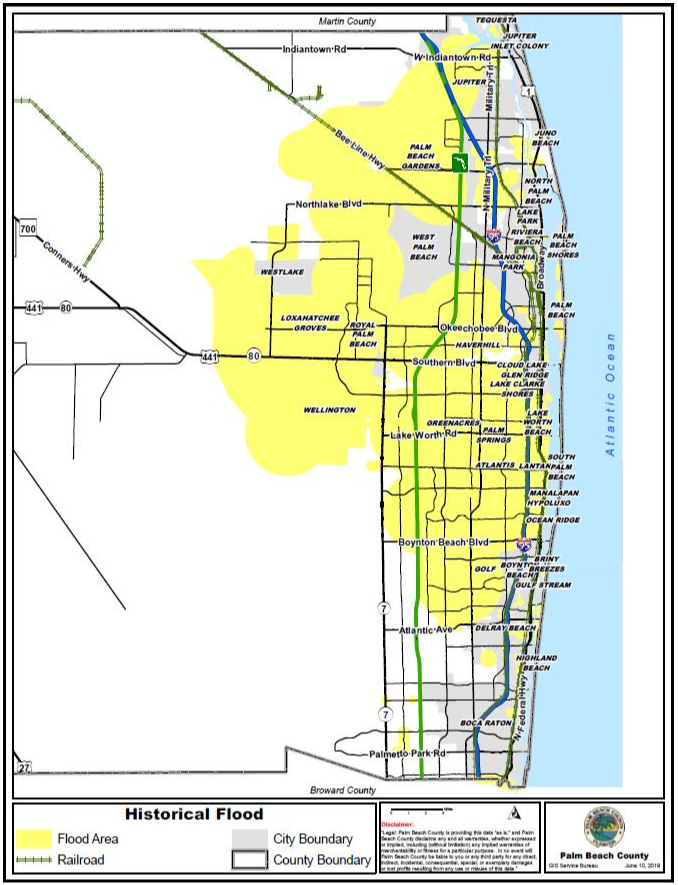
Flood Prone Areas
Flood prone areas are widely scattered throughout the county. Areas close to inland bodies of water and lower elevation areas in the northern and southern sections of the county are particularly susceptible to inland flooding.
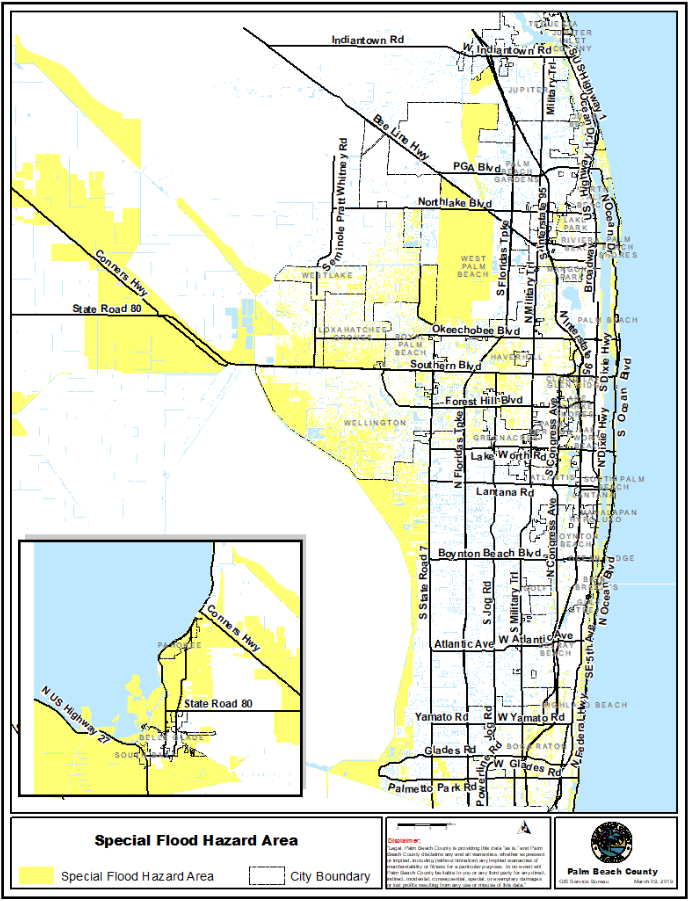
The map below depicts Special Flood Hazard Areas areas within the county designated by FEMA as having a one percent chance of inundation in any given year. While some areas of the county might believe they are immune from flooding based on recent history, published elevations, and/or designations on Flood Insurance Rate Maps (FIRMS), virtually the whole county has proven to be susceptible to short term localized flooding when extraordinary rain events have exceeded the capacity of natural runoff and absorption.
A review of recent flood events suggests that Palm Beach County significantly surpasses the national average of 25% of flooding occurring outside of Special Flood Hazard Areas. Even a significant number of county properties designated as "repetitive flood loss list" by the National Flood Insurance Program (NFIP) lie outside Special Flood Hazard Areas.
Historically, the Palm Beach County rainfall area has the highest annual rainfall in South Florida, followed by Broward County and Miami-Dade rainfall areas. The county’s east coast communities receive higher rainfall levels than the inland and western areas. Even during drought years, there have been instances where the coastal rainfall in eastern areas of the county were close to the average. Because there are no large impoundments in the eastern coastal rainfall areas, runoff has to be discharged into the Atlantic Ocean.
The map below shows areas in Palm Beach County that are prone to flooding:
Flood Control
Flood control in Palm Beach County is dependent on a complex, integrated system of canals, waterways and flood control devices operated by the South Florida Water Management District, 20 drainage districts, and thousands of privately owned canals, retention/detention lakes and ponds.
The county's drainage system is designed to handle excess surface water in three stages. The "neighborhood or tertiary drainage systems" (made up of community lakes, ponds, street and yard drainage grates or culverts, ditches and canals) flow into the "local or secondary drainage system"(made up canals, structures, pumping stations and storage areas) and then into the "primary flood control system" (consisting of South Florida Water Management District canals and natural waterways and rivers), ultimately reaching the Atlantic Ocean.
Storm Drains
If you live in an HOA community, please contact your HOA. If you live on a County maintained road, please call the Palm Beach County Road and Bridge Division at 561-684-4000. Or, if you live in a neighborhood that is part of an Improvement District (ITID, SIRWCD, NPBCPD, etc.), please contact your respective Improvement District.
The Water Control Districts serving Palm Beach County include the following:
| South Florida Water Management District |
| Acme Improvement District | Pahokee Drainage District |
| East Beach Water Control District | Pelican Lake WCD |
| East Shore Water Control District | Pine Tree WCD |
| Gladeview Drainage District | Ritta WCD |
| Highland Glades Drainage District | Seminole WCD |
| Indian Trail Improvement District | Shawano Drainage District |
| Lake Worth Drainage District | South Florida Conservancy District |
| Loxahatchee Groves WCD | South Indian River WCD |
| North Palm Beach Heights WCD | South Shore Drainage District |
| Northern PBC Improvement District | WPB Water Catchment Area |
Drainage System Maintenance
Palm Beach County's drainage systems consist of a combination of natural drainageways and channels, engineered channels, storm sewers and ditches, and detention/retention basins contiguous to drainage systems. These systems can easily lose their carrying capacity with debris accumulation, sedimentation buildup and/or vegetation growth, becoming ineffective for flood prevention. Extensive maintenance is necessary to ensure flood preparedness.
Responsibility for inspection and maintenance of drainage systems falls to a variety of organizations depending on the type of system involved:
- South Florida Management District and the various water control districts provide oversight for the routine inspection of the drainage systems under their purview and for debris clearance and other maintenance activities.
- Storm drain maintenance falls within the purview of the County's Road & Bridge Division, municipal public works departments, and the State Department of Transportation.
- Inspection, clearance, and maintenance of privately owned systems are the responsibilities of property owners and associations.
In rare instances, environmental regulations may prohibit removing natural debris and new growth from some drainageways.
Maintenance activities, most commonly, include ongoing monitoring, debris and sediment removal, and the correction of problem sites and damaged systems by field crews. Quite often, maintenance actions are prompted by citizen complaints and reports. Given the shear size of the County, the vigilance of citizens is a critical element in identifying potential drainage problems. The County has ongoing programs for structural and permanent changes to channels or basins (e.g. enlargement of openings, installation of grates to catch debris, installation of hard bank protection, construction of new retention basins, etc.) to reduce flooding and maintenance problems. Coastal communities commonly undertake a variety of maintenance measures including dune and mangrove preservation, bluff stabilization, and beach nourishment to protect coastal buildings, property, and coastal water bodies from flooding and erosion.
The county and municipalities work continuously to improve and maintain their stormwater management systems. Some of these projects are self funded and others depend on grant support. Drainage improvement projects are among the most prevalent flood mitigation strategies reflected on the County's Local Mitigation Strategy prioritized project list.
Dumping materials into our waters or drains pollutes the waters, clogs the storm drains, and increases flooding in neighborhoods. Please call the Engineering Department at 561-684-4000 for more information about stormwater management, or Code Enforcement at 561-233-5500 to report illegal dumping.
Vulnerability
While damages caused by storm surge and dike failure can be extensive and costly, historically physical damages from inland structural flooding have been relatively minor and isolated. As a predominantly localized event, inland flooding does not pose a significant threat to the ability of the county, municipalities and businesses to carry on normal operations.
People, structures, and infrastructure located within floodplains and areas with poor drainage are most susceptible to inland flooding, particularly to flash flooding. However, flash flooding can and does affect all areas of the county. Continued development will certainly contribute to an increased frequency of runoff flooding.
For the most part, flooding depths are not sufficient to inundate large residential and commercial areas. Developed parcels tend to be elevated to a level that limits significant water intrusion from water build-up. Where water does intrude structures, damage can be costly for individual property owners. Beyond physical water damage, perhaps the greater issue is the potential for mold infestation, which can create health problems for occupants and lead to costly cleanup and repairs.
Flooding can cause damage to cars and outdoor equipment, contaminate water systems, and interrupt water treatment. Sewage overflow raises health concerns.
Significant expanses of street flooding are common, can be costly in terms of loss of function for extended periods of time, and can create dangerous, even potentially deadly, driving conditions.
Post storm accidents, especially electrocutions, are not uncommon, when people wander into flood waters where live wires or generators are present.
Below is a map of the Special Flood Hazard Area in Palm Beach County